Villa Maria, Beaconsfield

Figure
1: Private Donor,
Villa Maria verandah, Myli Local History Archive.
Early
Owners of the Land:
The land on
which Villa Maria (also known as Villa Mar) rests on is traditionally recognized as belonging to the
Bunurong People of the Eastern Kulin nation.
After
European colonization, the area we now know as Beaconsfield was once called
‘Little Berwick[1].’
The land which surrounds the Villa was once leased out as a pastoral run named
Panty Gurn Gurn. In the Upper Beaconsfield Early History, C.W Wilson
sites the first European owner of the land as C.F Jackson. The property then
passed to Thomas Jackson in the 1840s and to William Bowman in 1850 before
David Bowman was given preemptive right in 1853[2].
The
Cardinia Heritage Study reports that a C.F Henry who owned land next to Panty Gurn
Gurn requested Lots 34 and 35 were removed from the run[3]. In the 1870s the O’Neil
siblings acquired lots of land surrounding Panty Gurn Gurn. From 1878, maps
indicate an E. O’Neil occupying Lot 53, M. O’Neil in Lot 34, and John O’Neil
holding lot 54.
It is
thought that David Bowman’s slab and bark hut was built around the area where
the current Villa Mar is located[4]. This historical map overlay of the run viewed on the Public
Records Office of Victoria’s Map Warper shows a public house on the north-west
corner of the property, and an old hut on the lower eastern boundary near the
current Glismann Road. Another hut is also mentioned in Michael O’Neil’s probate
record. You can also read more about Michael's death here, after being kicked in an altercation at the old Gippsland Hotel.

Figure
2: Overlay of map of Panty Gurn Gurn and Beaconsfield today from PROV Map
Warper, PROV

Figure
3: Overlay of map of allotments in 1878 from PROV’s Map Warper, PROV
This map overlayed
with a current map of Beaconsfield today shows property holders from 1878 in
the County of Mornington indicates Villa Mar is located on Michael’s old Lot.
O’Neil Road, named after the family in 1879[5], runs directly through
Michael’s old property, through the northern boundary into John’s property
before running through the north-east corner into an M. Officer’s land. Located
just off O’Neil’s road on Michael’s property is Villa Mar Rise, where the Villa is located today.
Interestingly,
rate books from 1876 and 1877 list Lots 53, 54 and 34 in Pakenham Riding as
being under John O’Neil’s name, despite the above maps. Below are images from
the 1876 rate book.


Another map found on Upper Beaconsfield History,
presumably dated to after 1879 and most likely after 1880 due to the presence
of O’Neil Road lists John as the executor of Michael O’Neil’s estate[6]. Michael actually appears
to have passed in 1874, the same year as his mother Catherine, with John
passing in 1852. Their memorial was erected at Berwick Cemetery[7]. Michael’s probate directs
the property be left to his two brothers, John and William. The 174 acre
property held a wattle and daub hut of two rooms[8]. In John’s probate of 1882, in which Elizabeth Savage is listed
as committed, we can see John holds two properties, one of which has a wattle
and daub hut of 5 rooms, while the other has no hut. Edward Savage, Elizabeth’s
husband is listed as executor. After their deaths, the property was apparently
gifted to the Sisters of Charity.
C.W Wilson[9] states that a William
Brisbane requested a road be placed running through O’Neil property. Elizabeth
Savage (nee O’Neil) consented, on the provision the road was named O’Neil road.
This William Brisbane may be the same W. Brisbane that occupied several
selections north and north east of the O’Neil properties, with O’Neil Road
running directly to two properties listed under his name (Lots 70, 77 and 64)[10].
In 1878 and
1879 Rate Books it appears a William Sanderson was renting the lots off of
John. Below is an image from the 1878 Rate Books.

From 1880,
the properties are occupied by Mrs Savage (Elizabeth O’Neil, but still under
John’s name. See below the rate book for 1880.

The
properties are then list John as the proprietor in 1881, 1882, 1883. See below
for 1881.

By 1880,
Beaconsfield was seeing further development, with the Panty Gurn Gurn estate
being subdivided[11]. After
this year John O’Neil disappears from the rate books with his apparent passing
in 1852. Lots 34, 53, 54 are now under an Francis E(?) Stewart, a banker from
1884. See below for the 1883-1884 rate book.
In
1888/1889 rate books F. Stewart appears again as occupier of lot 34, Michael
O’Neil’s old lot. See below.
I do
believe Stewart may have been renting the property, as from 1900 on Edward and
Elizabeth Savage (the sister of John and Michael) are listed as owners of the
land. See below.

Elizabeth
passed sometime in 1916, and her probate lists properties held.


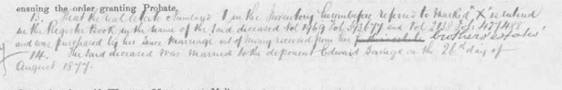
The last snippet
mentions her inheriting her ‘brothers’ estates.’ Further, lot 34 is listed as:

Figure
4: Elizabeth Savage’s probate and will, PROV.
In her will, she gifts a number of assets to the Roman
Catholic Church upon her husband’s death, due to the Villa already existing by
this point, it is most likely the Elizabeth and Edward were allowing the use of
the property even before Elizabeth’s death.
Villa
Maria/St Vincent’s Rest Home
In 1913, several
articles in The Advocate mention a Villa Maria Convalescent Home in
Beaconsfield being run by the Sisters of Charity having been opened, with one
stating the home opened a year past.

Figure
5: The Advocate, Villa Maria, 7 June 1913, TROVE

Figure
6: the Advocate, Visit to Villa Maria, Beaconsfield, 7 June 1913, TROVE
In 1915, The Advocate noted that the property had been purchased by
St Vincent’s hospital with the Sisters of Charity administering a home for poor
convalescents. Dubbed Villa Maria, and also known as St Vincent’s Rest Home,
the newly constructed building had numerous modern amenities including gas, hot
and cold water, and sewage.
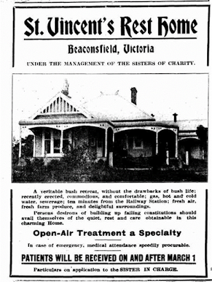
Figure 7:
The Advocate, St Vincent’s Rest Home, 20 February 1915, TROVE
The home
proved popular, with some 86 patients having attended[12], however the distance
from Melbourne proved to be too great and the home closed in 1916 only to open
again as a pensioner rest home under the name Villa Maria, run by Miss Ethel
Roper.[13]

Figure
8: The Advocate, Villa Maria, Beaconsfield, 14 October 1916, TROVE
In 1931, Rev. W.P. Hackett led a retreat for laymen.
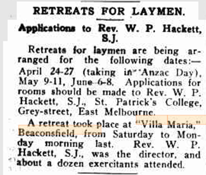
Figure 9: The Advocate, Retreats
for Laymen, 16 April 1931, TROVE
Alexander
S. Thomas and Rose G. Irvine purchased the property in the 1960s and continued
to run it as a rest home[14]. During the 1960s the
property had shrunk to around 4 acres in size and in in 2005 the property was
sold and is currently a private residence[15].
Architecture:
The Cardinia Shire (North) Heritage Study: Heritage
Places describes the building (est. 1890s) as being “…a Federation Bungalow styled farm
house sited at the top of a hill and concealed by a mature garden and trees
reached by a long drive from a picketed entrance… The complex includes an
Edwardian-era weatherboard former rest home with a corrugated iron room, 12
bedrooms, a kitchen, dining room, a former chapel and two bathrooms. There is
also a smaller contemporary house at the rear with three bedrooms and a veranda
which was reputedly once used by the priests and another cottage once occupied
by the farm manager. ”[16]

Figure 11: Private Donor, Villa Mar Driveway, Myli Local History Archive.

Figure 12: Private Donor, Villa Maria (building on the left original Cobb & Co. Coach house),Myli Local History Archive.
The Fedaration style bungalow building boasts original
joinery and ceiling details and the unique architecture including the interior
chapel, interior courtyard (a significant architectural feature) surrounded by twelve bedrooms hearkens back to the
building’s original purpose[17].
This floorplan, donated by a private donor to Myli’s Local History archive
gives an idea of the layout of the main building.


Figure 14: Private Donor, Interior courtyard, Myli Local
History Archive.

Figure 15: Private Donor, Interior of Villa Maria, Myli
Local History Archive.

Figure 16: Front door of Villa Maria currently with the original stain glass window, 2023, Private Collection
The building is also featured on the Cardinian Embroidery, on
display permanently at the Cardinia Cultural Centre.
[1]
Hicks, P., 1988, Berwick
Pakenham Corridor Historical Survey
[2]
Wilson, C.W, 2013, Upper Beaconsfield: an early history
[3]
Graeme Butler & Associates, 1996, Cardinia Shire Heritage Study: Volume
3 Heritage Places
[5]
Graeme Butler & Associates, 1996, Cardinia Shire Heritage Study: Volume
3 Heritage Places
[6]
Unknown creator, c.1870s, Parish of Pakenham, from Marianne Rocke (comp.), Residents
of Upper Beaconsfield and Surrounding Areas, https://www.upperbeaconsfieldhistory.org.au/land.htm
[7]
Find a Grave, 2023, John O’Neill, https://www.findagrave.com/memorial/216542727/john-oneill?_gl=1*8a0pfu*_gcl_au*MTU5MzQxNTUwMC4xNjgwNDk0MDkw
[8]
Find a Grave, 2023, Michael O’Neill, https://www.findagrave.com/memorial/216542757/michael-o'neill
[9]
Wilson, C.W, 2013, Upper Beaconsfield: an early history
[10] Unknown
creator, c.1870s, Parish of Pakenham, from Marianne Rocke (comp.),
Residents of Upper Beaconsfield and Surrounding Areas, https://www.upperbeaconsfieldhistory.org.au/land.htm
[11]
Unknown Creator, 1880, Plan of the town of Beaconsfield or East Berwick,
courtesy State Library of Victoria, identifier: 1586449, https://viewer.slv.vic.gov.au/?entity=IE15455272&mode=browse
[12]
Graeme Butler & Associates, 1996, Cardinia Shire Heritage Study: Volume
3 Heritage Places
[13]
Graeme Butler & Associates, 1996, Cardinia Shire Heritage Study: Volume
3 Heritage Places
[14]
Friends of the Cardinian Embroidery, 2006, Cardinian Embroidery
[15]
Friends of the Cardinian Embroidery, 2006, Cardinian Embroidery
[16]
Graeme Butler & Associates, 1996, Cardinia Shire Heritage Study: Volume
3 Heritage Places
[17]
Heritage Council Victoria, 2023, Villa Maria, Victorian Heritage
Database, https://vhd.heritagecouncil.vic.gov.au/places/30156